Species protection issues need to be addressed for a wide range of infrastructure projects. For example, in wind power projects in forests, it is important to know whether roosts or hunting grounds of bat species relevant to planning are affected by the intervention or whether the planned route of a road cuts through flight paths. Traditional manual radio telemetry is time-consuming, cost-intensive and often has spatial errors that exceed the specified distance limits.
In intervention procedures
Use of the trackIT system for species protection issues
In intervention procedures
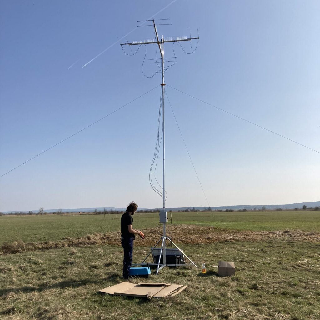
Location-based recording with the trackIT system
The trackIT system has been adapted and optimized in recent years to meet the needs of recording in planning projects. Automatic receiver units are placed at the planned intervention site at the beginning of the recording season and the space usage of the animals tagged is recorded systematically and in a standardized manner over the entire transmitter runtime.
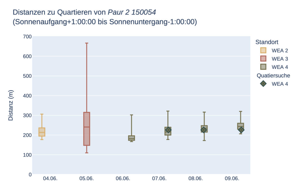
For each signal received, the distance to the planned intervention site is calculated using statistical methods. Both the use of roosts (Fig. 1) and of hunting grounds within the relevant distance radii can thus be recorded over the entire transmitter runtime.
While manual roost searches only take a fraction of the transmitter runtime into account, the trackIT system can be used to monitor roost use in the intervention area seamlessly over the entire transmitter runtime.
Fig.1: Example of the location-based recording of roost use in the intervention area. Boxplots represent the distance measurements of the trackIT system during the day, diamonds represent the actual distance of the roost to the monitoring station on the day of the roost search.
In which intervention procedures is the trackIT system used?
The trackIT system is used in various intervention procedures. These include highway projects, wind energy projects and mining projects.
Road construction
Windenergy
Mining
Comparative study
Recording and visualization of room usage
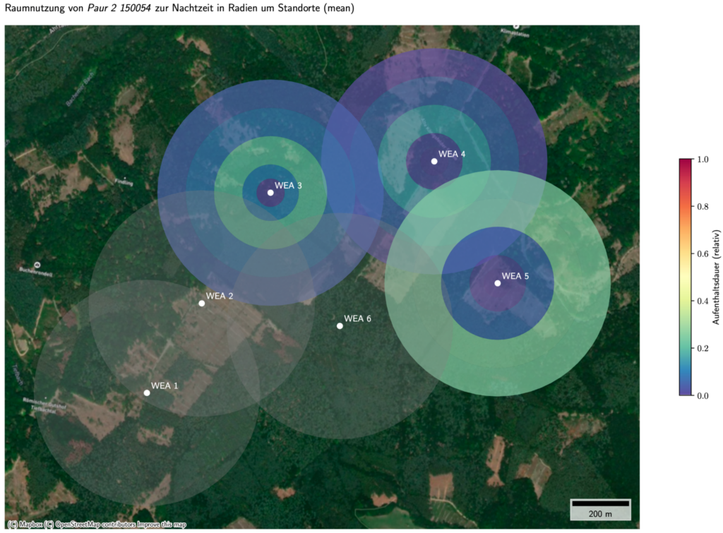
If the same signal is received on several trackIT stations at the same time, the position of the animal can also be determined using multilateration. The data is transmitted in real time and made available to the experts carrying out the assessment.
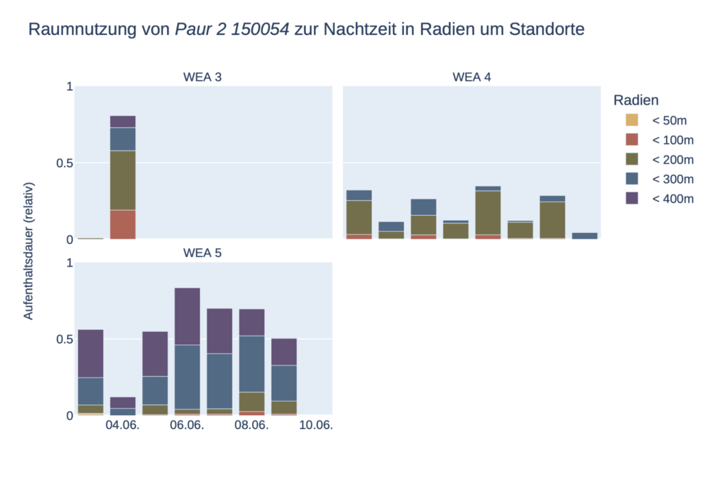
Fig.2: Duration of a bat’s stay within different distance circles (50 m, 100 m, 200 m, 300 m, 400 m) around planned turbine sites in relation to the night length (for each night as a bar chart (left) and averaged over the transmitter runtime (right)).
Fig. 3: Together with Simon und Widdig GbR, Bechstein’s bats were recorded in a highway project using both automatic (gray dots) and manual (red dots) telemetry. The results show a similar assessment of the space used, whereby the automatic telemetry determines a multiple of the positions by processing each transmitter signal over the entire transmitter runtime and records both flight paths and hunting areas in a more differentiated manner.
Real-time data for Experts
Efficient species conservation assessment with trackIT Systems: real-time data for experts
Thanks to the high temporal and spatial resolution of the trackIT system, species protection issues can be answered much better and more precisely than would be possible with traditional manual telemetry. Problems relating to species conservation can be identified immediately during ongoing seasonal operations and the resulting changes to planning can be adapted in a time-efficient manner. This generates a significantly improved data basis for species conservation assessments and also significantly speeds up, standardizes and reduces the costs of the investigation process.
The trackIT system is now a standard method in Rhineland-Palatinate and is also used in other federal states to record essential hunting areas and the use of roosts by bat species relevant to planning.
The project is investigating the decline of the oystercatcher in Schleswig-Holstein. trackIT Systems is tagging chicks in Beltringharder Koog to analyze survival rates and predation. Conservation measures are developed through continuous data transmission. The project runs until 2025.
The trackIT system in the
meadow breeder protection
The project investigates when and why the chicks die in the dangerous phase between hatching and fledging and what measures can be taken to increase breeding success. The project has been running since 2021.
Lapwing and black-tailed godwit populations
of the Dümmerniederung
Since 2023, the Natur- und Umweltschutzverein Dümmer e.V. (NUVD), BIOCONSULT Osnabrück and the NLWKN have been studying the chicks of wetland limicolous species in the Dümmer lowlands using the trackIT system.
And many more projects that can be realized with you in the future…